How Does GPS Know Where You Are? | How It Works Inside #05
Short answer
- GPS turns signal travel time into distance and solves place plus clock error with four satellites.
- Signals cover about 20,000 km in about 0.07 seconds; time times speed gives distance.
- The four unknowns are east–west, north–south, height, and clock error, so four satellites are needed.
Also calledhow GPS workswhy GPS needs four satelliteshow phones know location
Video

Pressing play loads the YouTube player on this page. Watch on YouTube
Explained
The satellites, phone, and buildings in the figures are illustrative models, not to scale. Satellite positions were calculated from orbit data for noon Japan time on October 17, 2026. Where devices differ, we write "typically." To watch this in motion, see the full video of this episode.
The whole idea in 30 seconds
- GPS satellites keep broadcasting the time they sent each signal and their own positions. Your phone only listens; the satellites do not know where your phone is.
- The phone picks each satellite's pattern out of noise and measures how long the signal took to arrive.
- Multiply that time by the speed of radio waves (about 300,000 km per second) and you get the distance: roughly 0.07 seconds, roughly 20,000 km.
- With four satellites, the phone solves four unknowns together: east–west, north–south, height, and its own clock error.
GPS satellites: lighthouses with clocks
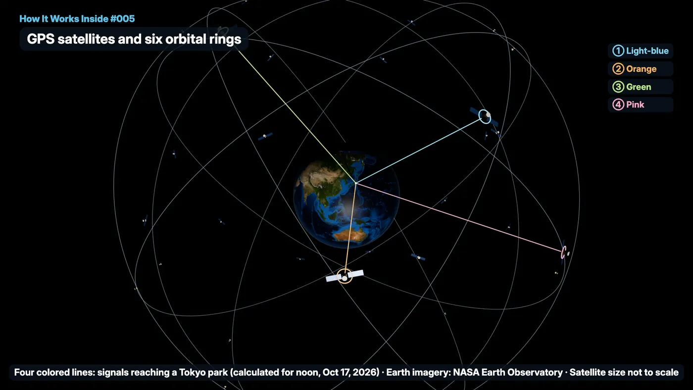
GPS is a U.S.-owned system. The space and control parts are developed, maintained, and operated by the U.S. Space Force, and the civilian service is freely available to everyone worldwide. The satellites fly about 20,200 km up, circle Earth twice a day, and are arranged in six orbital planes. More than 30 are in operation (32 in the orbit data for October 17, 2026).
A key point: GPS satellites track nothing on the ground. They broadcast one-way signals, like lighthouses. People often imagine the satellite "telling" the phone its position. In reality, the phone computes its own position from what the satellites broadcast.
Atomic clocks and the time sent
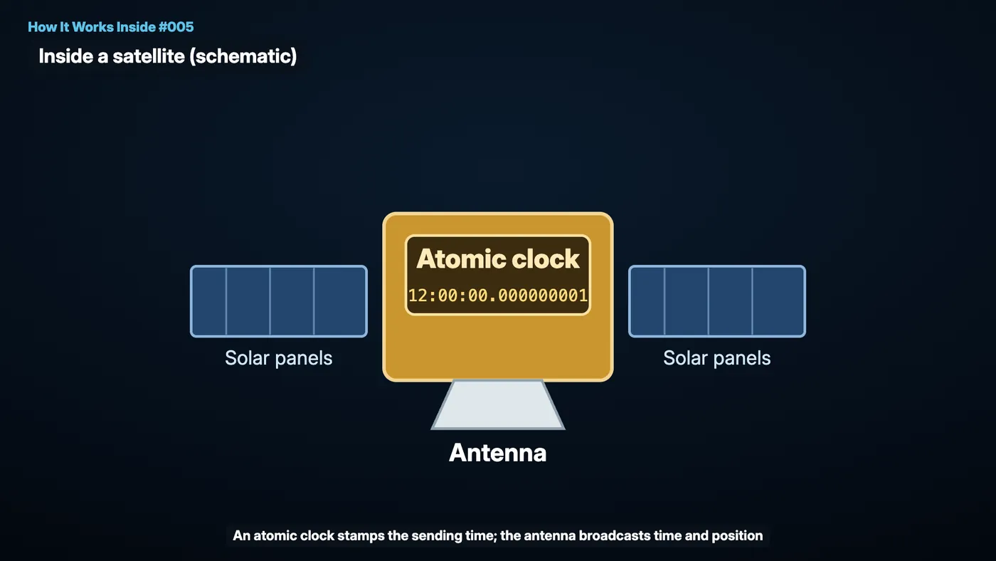
Each satellite carries an atomic clock, and the sending time is stamped with nanosecond precision. That stamp becomes the ruler for measuring distance.
How a satellite knows its own place
Satellites also broadcast orbit information: a detailed ephemeris for themselves and a coarse almanac covering the whole constellation. An orbit can be written as a function of time, so inserting an exact time gives the satellite's position. Ground control stations compute these orbits and upload them to the satellites.
Satellite clocks and relativity
Seen from the ground, an orbiting satellite's clock runs slightly fast, mainly because of gravity. The gain is about 38.6 microseconds a day. GPS satellite clocks are therefore set to tick slightly slower before launch, so they keep the right rate as seen from Earth. You may hear the claim that "otherwise GPS would drift 11 km a day." That is an oversimplification we do not use here.
The path inside your phone
Inside the phone, every signal passes four gates.
1. Receive
All GPS satellites broadcast on basically the same frequency (the L1 band, 1575.42 MHz). After traveling some 20,000 km, the signals are extremely faint and buried under natural noise.
2. Pick out
Each satellite uses a different code, a pattern of ones and zeros. The receiver slides a satellite's pattern along the incoming wave until it lines up; at that point the signal rises out of the noise and the arrival time is fixed. The code runs at 1.023 million bits per second, so one code chip corresponds to about 293 m. Receivers read much more finely than that and measure distance to within a few meters. Several satellites can be received and read separately at the same time.
3. Read
Once the pattern locks on, a slow message at 50 bits per second becomes readable. It carries the satellite's position and the time the signal was sent.
4. Turn into distance
Distance equals travel time times the speed of radio waves. Of the satellites visible from Hibiya Park in central Tokyo at noon on October 17, 2026, this episode uses these four (calculated values):
| Satellite | Distance | Travel time |
|---|---|---|
| ① Light-blue (PRN 13) | 20,585 km | 0.069 s |
| ② Orange (PRN 23) | 21,052 km | 0.070 s |
| ③ Green (PRN 32) | 22,673 km | 0.076 s |
| ④ Pink (PRN 15) | 23,390 km | 0.078 s |
It is the thunderstorm rule, scaled up. Count the seconds between the flash and the thunder: sound covers about 340 m per second, so three seconds means about one kilometer (roughly five seconds per mile). Radio waves cover about 300,000 km per second, so about 0.07 seconds means about 20,000 km.
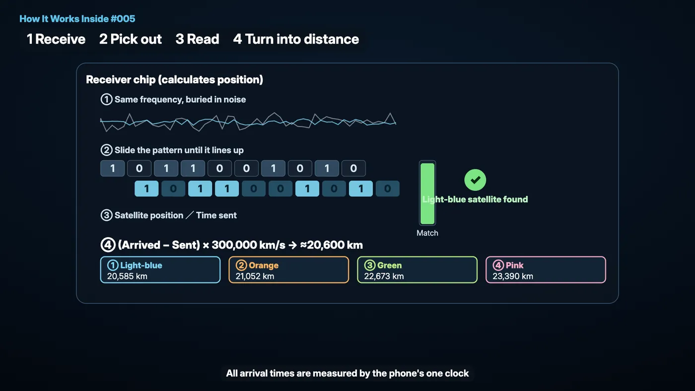
Keep one detail in mind: all four arrival times are measured by the phone's one clock. That is the key to the puzzle below.
From distances to a place: stacking spheres
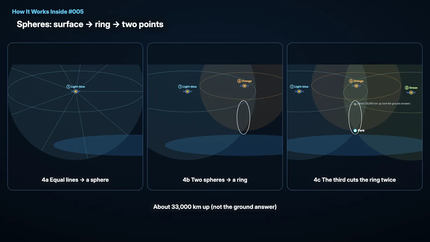
Stretch lines of the same length, about 20,600 km, from the light-blue satellite in every direction. Their ends form the surface of a sphere: with one distance, you could be anywhere on it. Add the orange sphere and the two surfaces meet in a ring. Add the green sphere and it cuts the ring in two places. One point is the park in Tokyo. The other is far out in space, about 33,000 km up, so on the ground the answer is the park.
The fourth satellite: the clock-error puzzle
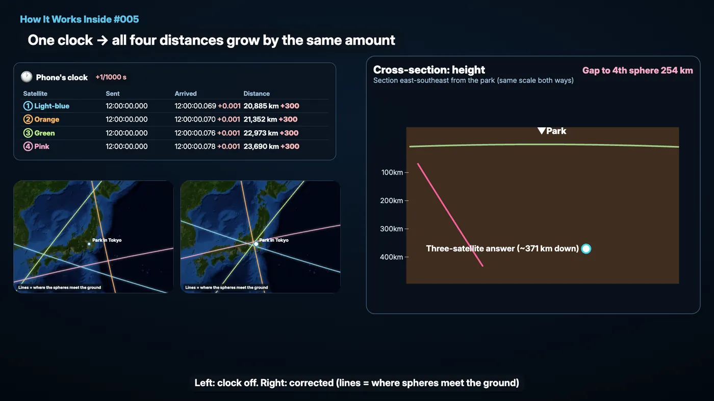
So far we assumed the phone's clock is exactly right. But radio waves travel 3 m in a hundred-millionth of a second, so a clock error becomes a distance error at the same scale: a thousandth of a second is about 300 km, a millionth is about 300 m, a hundred-millionth is 3 m.
Suppose the phone's clock runs fast by a thousandth of a second. Since one clock times all four signals, every distance grows by the same amount, about 300 km. The three swollen spheres now meet at a point about 110 km east-southeast of the park and about 370 km underground. The fourth, pink sphere misses that point by about 250 km.
The receiver therefore slides its assumed clock error, shrinking all four distances by the same amount, and looks for the place where all four agree. When the assumption reaches a thousandth of a second, the underground point rises to the park, and on the map the four lines where the spheres meet the ground cross at one point in Tokyo. The unknowns are four — east–west, north–south, height, and the clock error — which is why GPS needs four satellites. You can watch this moment in the clock-puzzle scene of the full video.
The receiver gains precise time along with its place. By decoding the signals it effectively aligns with the satellites' atomic clocks, knowing the time to within a ten-millionth of a second. GPS time is also used to synchronize cell towers. That does not mean the clock on your phone's screen is set by GPS.
City streets and the circle around the blue dot
The blue dot in a map app is your current location. When it cannot be pinned down exactly, some apps draw a light-blue circle; you are somewhere inside it, and a smaller circle means higher accuracy. On Android, that radius is defined so the true location is within it with 68% probability.
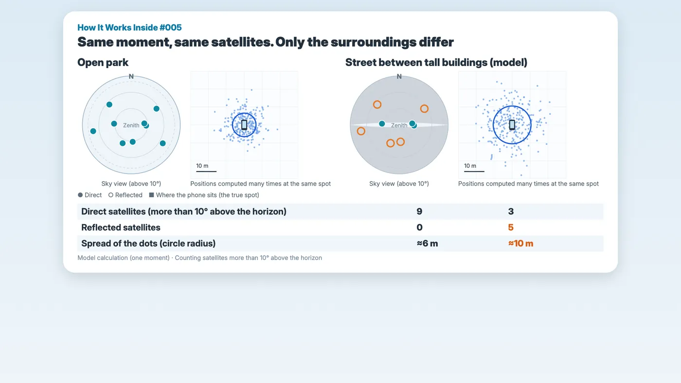
GPS-enabled smartphones are typically accurate to within about 4.9 m under open sky (GPS.gov, based on a 2015 measurement). Accuracy gets worse near buildings, bridges, and trees. One cause is reflection: a signal that bounces off a building takes a detour, arrives late, and is measured as farther away.
Park versus street canyon (a model calculation)
This model keeps the same moment, the same satellites, and the same math, changing only the surroundings. Only satellites more than 10° above the horizon are counted. The street is a 30 m wide east–west road flanked by 40 m buildings.
| Open park | Street canyon (model) | |
|---|---|---|
| Direct satellites | 9 | 3 |
| Reflected satellites | 0 | 5 (detours of about 5–17 m) |
| Circle holding 68% of computed positions | about 6 m | about 10 m |
| Average offset of computed positions | almost 0 m | about 4 m |
This is one model example, not a prediction of accuracy at any real place. The circle in the figure shows the spread of positions computed many times at the same spot; it is a different thing from the circle a map app displays.
Michibiki and satellites overhead
Michibiki, Japan's regional satellite navigation system (QZSS), works as one with GPS. Its quasi-zenith satellites linger almost overhead over Japan, so more signals can arrive directly even between buildings. In the model's full day, the median number of direct satellites in the street canyon rose from two to four when Michibiki was added. But more satellites do not always mean a smaller spread: if reflected signals join in, the cloud of points can grow, as it did at this particular moment.
The ionosphere delay
Signals slowing down in the ionosphere are the largest single source of ranging error, sometimes amounting to tens of meters. Receivers reduce it by using two frequencies or a correction model broadcast in the signal.
Indoors and underground
Indoors, satellite signals grow weak, so a receiver often cannot use them at all, or the position error becomes much larger — though signals can sometimes get through near a window. Underground malls and tunnels are essentially out of reach. Phones still show a location there because location services also use cell towers, Wi-Fi, and Bluetooth. Many current phones can use several satellite systems besides GPS.
Frequently asked questions
Does my phone send signals to GPS satellites?
No. GPS satellites are one-way beacons, like lighthouses, and they track nothing on the ground. That is separate from your phone using mobile networks to display maps.
Does using GPS cost money?
The GPS civilian service is freely available to all users worldwide.
Why are four satellites needed?
Because there are four unknowns: east–west, north–south, height, and the receiver's clock error. A clock error adds the same bias to every distance, so the fourth satellite lets the receiver solve position and clock error together.
Why does the first fix sometimes take a while?
Orbit information arrives slowly from the satellites themselves: the GPS navigation message takes 30 seconds per page and 12.5 minutes for all 25 pages. Phones can fetch the same data over the internet or mobile networks first, which shortens the wait.
Why does my phone know where I am indoors?
Phone location services combine GPS with cell towers, Wi-Fi, and Bluetooth. The satellite signals themselves are generally unusable indoors, underground, or in tunnels with typical receivers.
What is Michibiki's relationship to GPS?
Michibiki (QZSS) is Japan's regional system, designed to be used together with GPS, almost as if more GPS satellites were available. Its satellites stay near the zenith over Japan for long stretches, which helps signals arrive directly between buildings.
How accurate is it?
For a smartphone under open sky, within about 5 m is typical. With dedicated receivers and Michibiki's augmentation services, sub-meter and even centimeter-level accuracy are available.
Doesn't relativity break the satellite clocks?
Satellite clocks gain about 38.6 microseconds a day as seen from Earth. They are set to tick slightly slower before launch to cancel that out.
Where to read more
For GPS itself, GPS.gov (U.S. government) is the official overview. For the step-by-step geometry, Japan's Cabinet Office QZSS site has a four-part "treasure hunt" primer (in Japanese), plus explainers on CDMA signal separation and multipath reflections (in Japanese). For satellite clocks and relativity, see Ashby (2003). For the 60-second version, watch this episode's short video.
Sources
Where the facts and numbers in the video and on this page come from.
References
- Earth imagery: NASA Earth Observatory (Blue Marble Next Generation). Maps: GSI Tiles (Geospatial Information Authority of Japan).
Links
- GPS.gov (archived pages): "GPS: The Global Positioning System," "Space Segment," "Control Segment," "GPS Accuracy," "Timing." U.S. government. and related pagesarchive.gps.gov/systems/gps
- GPS.gov FAQ, "I lost my mobile phone/device. Can GPS help me find it?" U.S. government.gps.gov/faq
- Cabinet Office, QZSS (Michibiki) primers (in Japanese): "Understanding satellite positioning through a treasure hunt" parts 1–4 (2015); "Almanac and ephemeris" (2017); "CDMA" parts 1–2 (2017); "Multipath" (2016); "Measuring the ionosphere with radio" (2016); service and FAQ pages.qzss.go.jp
- Google Maps Help, "Improve your location's accuracy."support.google.com/maps/answer/2839911
- Android Developers, "Location.getAccuracy()."developer.android.com/reference/android/location/Location
- Apple Support, "About privacy and Location Services in iOS, iPadOS, and watchOS" (2026, Japanese page consulted).support.apple.com/ja-jp/102515
- Apple, "iPhone 17 — Technical Specifications" (in Japanese).apple.com/jp/iphone-17/specs
- ESA Navipedia, "GPS Navigation Message."gssc.esa.int/navipedia/index.php/GPS_Navigation_Mess…
- Neil Ashby, "Relativity in the Global Positioning System," Living Reviews in Relativity 6, 1 (2003).pmc.ncbi.nlm.nih.gov/articles/PMC5253894
- Japan Meteorological Agency, kids' FAQ on thunder and lightning (in Japanese).jma.go.jp/jma/kids/kids/faq/a3_16.html
- BIPM, "SI defining constants" (speed of light 299,792,458 m/s).bipm.org/en/measurement-units/si-defining-consta…
- CelesTrak GP data, "gps-ops" (orbit elements for October 17, 2026).celestrak.org/NORAD/elements/gp.php
- qzss.go.jp/overview/column/intro01_150918.html
- qzss.go.jp/overview/column/multipath_160704.html
Voice, music, art
- Music (OpenTracks): “なんでしょう?” by KK / “ちょっと楽しい” by 天野 七祈 / “探偵推理中” by 田中芳典 / “ensolarado” by Kyaai
- Fonts: Noto Sans JP, Inter, M PLUS Rounded 1c (SIL OFL 1.1)